A stratovolcano resembling a giant ballerina tutu skirt crowned with thick clouds defines the landscape of this corner of the Caribbean, making grounds for several hiking trails on Nevis island. The flanks of the dormant volcano, covered in lush vegetation with thriving wildlife, offer hikes with different levels of difficulty to suit every taste, and an opportunity to mix your beach vacation and to experience Nevis in a different way.
Disclosure: This post contains some affiliate links. If you make a purchase through those links I will earn a commission at no additional cost to you (zero, nada). To check the full disclaimer, click here.
These are the best hikes on Nevis island

Table of Contents
Russell’s Rest Trail (Nevis Waterfalls)

The massive swirling tree roots rolling into coves and the calming sounds of the waterfalls and the ravine made Russell’s Rest my favourite trail in Nevis.
The abandoned sugar mill you find near the trailhead gives you a hint about the past: this used to be the old Russell plantation. We walked on a wide grassy path until we saw the “To Waterfalls” sign.


From then on the trees became taller and denser and the trail became narrower, with muddy patches and rocky sections alternating with root blankets.


I loved stepping on the tall, ribbon-like roots of the huge ceiba trees, looking at the magical rainforest surroundings and listening to the birds. You start encountering the first ropes as you approach the first waterfall (there are six falls).


Beyond this point the hike gets steeper (more ropes) and narrower. The most difficult section is where the last two waterfalls are (we didn’t get that far). Bring some gloves to make your life easier if you want to visit all six waterfalls.
If you can only do one trail while you’re in Nevis, do the Russell’s Rest Trail.
This trail has moderate difficulty and a duration of around three hours if you want to visit all the waterfalls.
How to Get to Russell’s Rest Trail (Nevis Waterfalls)
The trail is located in the St. James Windward Parish, on the east side of Nevis.
Get off Zion Road and drive down the side road before/after (depending on where you’re coming from) the First Baptist Church of Maddens. Take the first right as if you were going towards the Prison Farm.
Right after you see the ruins of the sugar mill, you’ll find the trailhead sign on the left and the parking sign.


Follow the arrow and walk left on the grassy path to access the trail.
Saddle Hill Hiking Trail

Saddle Hill is located on the south end of Nevis, offering fabulous views of Nevis Peak, the slopes of Taylors Pasture, and the island of Montserrat.

We drove on the dirt road leading to the hill until we reached a fork, from where we started hiking on the left side (it doesn’t matter which one you take since it’s a loop). It didn’t take long to see why the hill got its name: the shape mimics a perfect saddle.


If you keep going up beyond the return point of the loop you’ll reach the cell towers at the top. We were hoping for a “view from the top” reward but the vegetation blocks everything so if you go there do it only for the sake of hiking.
We were also on the lookout for remains of the Saddle Hill Fortress, a battery built in the 1740s to shelter civilians in case of an invasion and to keep an eye for enemy ships sailing from the south. We only saw the sparse remains of an old stone wall, and a couple of donkeys.

By the way, the fortress was never used and not a single shot was fired from here.
Compared to other hikes in Nevis this isn’t the most spectacular, but the view you see on the way down is worth it. It’s an easy to moderate hike.
For an extra dose of awesome views you can (at your own risk) go into an abandoned construction you’ll see at the end of a dirt path, a few feet before reaching the fork.
How to Get to Saddle Hill
Go to the Gingerland area on the southwest side of Nevis. Get off the main road (Zion Road) and drive south at the Chicken Stone Junction (down Eva Wilkins Road).
Follow the map and you’ll see the blue sign for Saddle Hill Fortress (this is a stop in the Nevis Heritage Trail) as you get closer. You’ll hit a winding uphill dirt road that is better suited for a 4X4 SUV.
If your vehicle takes you as far as the fork up on the dirt road you can start your hike at the beginning of the loop.
The Source Hiking Trail
This beautiful hiking trail starts at a fabulous boutique hotel, the Golden Rock Inn, and goes up to “The Source”, as in the source of freshwater for Nevis, in the form of a spring high in the mountain.
First thing is to go to the Golden Rock Inn office located right at the entrance and get a printed trail map -hand drawn in a 8.5” x 11” sheet- that includes a few landmarks and notes.
We had no problem finding our way with the basic map.
The trailhead is a few steps inside the wooded area behind the covered parking at the inn. After going through a gate we took the concrete stairs and turned right to go uphill on a shaded grass path flanked with tall trees, leading to a concrete road.


We passed a big water reservoir and turned right into another grass path. From here the trail will start as a wide, relatively smooth terrain, morphing into a narrower trail covered with small to medium-size rocks, some of them covered in moss (read: slippery).


The large, dense trees with big ferns covering their roots not only offer shade, but also a home to many birds and to the African Green monkeys that you see all over the island. We heard their call before catching them looking at us from the forest. At several points we walked next to the pipes bringing freshwater from the spring and next to long vines stretching beyond our sight.


It gets a little bit more treacherous as you go up and right after the second ocean view point is where the real challenge begins, as you’ll have to descend through old concrete stairs completely covered in moss (read: beyond slippery).
We decided not to go ahead, you can’t breeze through these stairs.We didn’t have enough time to descend safely, reach the 120-foot “ladder” to “the source” and make our way back before it got dark (we did this at the winter solstice on the shortest day of the year).
Even if you don’t make it past the mossy stairs on the last section of the trail (not recommended if you’re afraid of heights), it’s still worth doing it to enjoy the hike through the gorgeous forest.
Don’t be like me and give yourself enough time to complete the hike: around four hours. I spent too much time roaming around the stunning gardens of the Golden Rock Inn (can you blame me?) before hitting the trail in the afternoon. Do the hike first and relax at the gardens later.
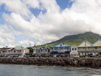
Nevis Peak

It’s impossible to miss. Nevis Peak rises in the middle of the island of Nevis at 3,232 feet, often surrounded by a cloud.
Minutes after meeting a local we inquired about this hike. She did it once and she shared this:
-If you’re hoping to come down with a picture of the view at the top there’s a great chance you’ll be disappointed.
This reminded me of Mount Scenery in the island of Saba (also in the Eastern Caribbean). There’s a cloud forest at the top and most of the time it’s surrounded by, well, a cloud. The one time she was at Nevis Peak it was clear and she enjoyed the marvelous view, but she knew another local who has made it to the top a dozen times and saw nothing but haze every single time. You may be as lucky as her. Or not. You can still enjoy the views on your way up.
-It’s not your average “difficult” trail, it’s a strenuous hike. It’s muddy -bring hiking shoes-, steep, with sections where you must pull yourself up with ropes -bring gloves- and hold on to tree roots with nothing stopping you from falling into the cliff. If you’re prepared it may be fun.
-Go with a guide: the local guides have grown climbing the mountain and they know it like the palm of their hands. They know the best way to get up there (and to get down).
After learning this and after rain pouring for several days during our stay we decided to pass.
Even though it’s always muddy around the peak I would be more open to trying it during the dry season and making it as far as I feel relatively safe.
I wanted to tell you about this hike anyway because it’s a thing to do in Nevis if you’re looking for a thrilling outdoor experience. Are you going for it?
Don’t miss the chance to experience this island from a higher perspective by exploring its scenic hiking trails and adding some excitement to your beach vacation. Want to know what else you can do? Check out my post about things to do in Nevis other than going to the beach.
YOU MAY ALSO WANT TO READ
BOOKING FLIGHTS AND ACCOMMODATIONS
To get from A to B without losing your shirt
Skyscanner: to find cheap flights. Get notified of price drops with the “Price Alert” feature or use “Search Everywhere” to see where you can go without breaking the bank.
Busbud: to book bus tickets everywhere.
To find a place to stay for less
Booking.com: this site combines everything under the sun. You’ll find hotels, apartments, B&B, hostels, rooms, etc., with all sort of filters to make your search a breeze.
Hotwire: the first site I check when we plan to stay at a hotel for a few nights. You can save anything from 20% to 60%. Use the search filter to find what you want and you’ll end up with three listings that match your criteria. You’ll know which one you’ll get after you book. If you can handle a little bit of uncertainty you can score big savings.
House Sitting: you take care of people’s pets and house for free while staying for free. It’s the closest thing to experiencing a place “like a local”. But it comes with responsibilities… Are you an animal lover? It may become your new way to travel.
To get travel insurance
SafetyWing: travel medical insurance that gives us peace of mind knowing that we’re covered in case of emergency. It’s convenient, affordable, and suitable for digital nomads who spend a long time outside their home country.
Check the full list of travel resources on my Resource Page for more options and savings
Amazing information!
Great photos!
I love this blog!
Thank you!!!!
Hi,
How long did you hike for on the Waterfalls trail? We hiked it the other day and didn’t really see any Waterfalls (but a lot of dried up areas that looked like they used to be Waterfalls with pipes taking water downhill which could be the reason for this?!?).
We walked up for about an hour but didn’t see any ropes either.
Hello!
I reached the first waterfall within 1.25 hours (including stops to take pictures). It’s a small one and if you go during the dry season (although with this crazy weather we don’t know anymore when to expect rain) it will probably look more like a trickle. The ropes to the second waterfall are to the left of the first fall, right next to it. Unless someone took them down!